Rim Country Short Term Rentals

By Central Arizona Association of REALTORS® President Dennis Riccio
Every so often, a buyer asks a question that reminds us how important local knowledge and due diligence are in our profession.
Recently, I was working with buyers relocating from Montana who were interested in The Rim Club. As they explored the area, they noticed the former aggregate operation near Highway 260 and Tyler Parkway. To many longtime Payson residents, that site may simply be part of the local landscape. But to these buyers, it raised an immediate concern.
They had seen areas in Montana where gravel pits and mining-related activity changed the look and feel of communities over time. They were concerned about whether the Payson site was active, whether it could expand, and whether similar operations could affect the area in the future.

Those were fair questions. They were also questions that deserved facts rather than assumptions.
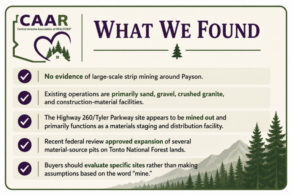
Based on the information I reviewed, the site near Highway 260 and Tyler Parkway appears no longer to be an active extraction site. It appears to b mined out and now functions more as a materials clearinghouse, staging, or distribution location for material coming from other sources. That same mine owns the corner property on the other side of Tyler Parkway with no current plans to mine that land. That information helped the buyers better understand what they were looking at and gave them more confidence in their decision-making.
But the experience raises a broader point for all of us.
Buyers today are not just looking at the home. They are looking at the surrounding land, future development, roadways, wildfire risk, water, zoning, viewsheds, and nearby industrial or commercial uses. When they ask about “strip mines,” they may not be using the technical term correctly, but the concern behind the question is real.
When a buyer raises this kind of concern, a good response might be:
“I understand why that would concern you. Let’s identify the exact site, determine whether it is active, inactive, reclaimed, proposed for expansion, or used for staging, and then check the appropriate public records before drawing conclusions.”
That approach does three important things. It validates the buyer’s concern. It avoids speculation. And it moves the conversation toward reliable information.
One of the most important things REALTORS® can do is help clients use the right vocabulary.
When most buyers hear the word “strip mine,” they may picture large coal-country surface mines that remove long strips of earth across a landscape. That is not what the public record primarily shows around Payson.
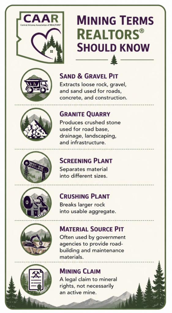
Around Rim Country, the more common operations are construction-material operations. These may include sand and gravel pits, crushed granite operations, rock quarries, screening plants, crushing plants, and county material-source pits used for road work.
These operations generally serve a practical construction purpose. They provide materials used for roads, driveways, concrete, drainage, utility work, road base, erosion control, and other infrastructure. In simple terms, if an area is building homes, repairing roads, improving infrastructure, or maintaining forest roads, it needs rock, gravel, sand, and aggregate from somewhere.
A sand and gravel pit typically removes loose or semi-loose material from the ground. That material may be sorted, washed, screened, or crushed into different sizes.
A granite or rock operation may involve extracting harder stone, then crushing it into usable material for construction, road base, landscaping, or concrete-related uses.
A screening plant separates material by size. A crushing plant breaks larger rock into smaller usable material. A batch plant or materials yard may store, mix, load, or distribute materials without necessarily being the place where the material was originally mined.
That distinction matters. A site with piles of rock, loaders, trucks, or equipment may look like an active mine to a buyer driving by, but it may actually be a staging yard, distribution site, processing facility, or former pit rather than a current extraction site.
Based on available public records, the Payson-area issue is not “strip mining” in the classic coal-country sense. What is documented in and around the broader Payson trade area is a mix of construction sand and gravel operations, crushed granite activity, screening and crushing plants, county material pits for road work, and scattered mining claims on public lands.
That distinction matters.
A gravel pit, granite quarry, material-source pit, screening plant, historic mining claim, and active mine are not all the same thing. They may look similar to a buyer driving by, but they can have very different legal, regulatory, and practical implications.
The research identified several examples of extraction-related activity in the broader region, including surface operations classified as construction sand and gravel, crushed granite activity in Star Valley, and Payson Concrete & Materials’ public statement that it performs mining, crushing, scheduling, and delivery from locations including Payson, Pine, and Tonto Basin.
There is also a forward-looking issue REALTORS® should be aware of. Gila County and the U.S. Forest Service recently advanced environmental review for four material-source pits on the Tonto National Forest: Braddock, Ramer, Castle Dome, and 824, also known as Bottle Springs. County records identify Ramer and 824 as being in the Payson-PV district, while Braddock is in the Tonto Basin district. The Forest Service project record shows a decision signed June 8, 2026.
In plain English, this means material-pit activity and expansion are not imaginary topics in northern Gila County. They are real land-use issues. But they should be discussed accurately and calmly.
Even when an operation is not a classic strip mine, buyers may still have legitimate concerns.
Depending on the site, buyers may ask about truck traffic, dust, noise, visual impacts, hours of operation, reclamation, future expansion, and whether the site could affect nearby property enjoyment or value. Those concerns are often highly site-specific.
Distance matters. Topography matters. Road access matters. Whether the site is active, inactive, reclaimed, or used only for staging matters. A former pit used for materials storage is different from a newly approved expansion area. A historic mining claim is different from an operating gravel pit. A county road-material source in the national forest is different from a private commercial quarry near residential property.
That is why REALTORS® should avoid broad statements and focus instead on identifying the exact site.
The Montana concern my buyers raised was useful because it showed how experiences from other markets shape buyer perception.
In parts of Montana, including areas around Bozeman and Gallatin County, growth, construction demand, and gravel extraction have become significant community issues. Buyers who have watched that happen may naturally worry when they see a pit, quarry, stockpile, or material yard near a neighborhood in Arizona.
Payson is different. Our area is heavily influenced by Tonto National Forest, public-land management, road-material needs, and federal review processes. That does not mean future activity is impossible. It means the analysis is different.
We should not import another state’s fact pattern into our market, but we should take buyer concerns seriously.
When buyers ask about mining or gravel pits, the best answer is not a prediction. The best answer is a process.
It is appropriate to say:
“There are aggregate, sand, gravel, granite, and material-source operations in the broader region.”
“Many of these operations support construction, road maintenance, concrete, and infrastructure needs.”
“It is important to identify the exact site and determine whether it is active, inactive, reclaimed, proposed for expansion, or simply used for staging or distribution.”
“Buyers should review public records and contact the appropriate agencies before making assumptions.”
It is risky to say:
“That site will never expand.”
“Nothing can happen there.”
“That mine is permanently closed.”
“There is no issue.”
“That operation will definitely become a problem.”
Unless you have verified records supporting the statement, avoid making predictions.
When a buyer has concerns about a nearby pit, mine, quarry, or material yard, encourage them to investigate through primary sources such as Gila County Development Services, Town of Payson Planning and Zoning, the Arizona State Mine Inspector, the Arizona Department of Environmental Quality, the U.S. Forest Service, the Bureau of Land Management, the Mine Safety and Health Administration, and county zoning, GIS, and agenda records.
Buyers should also consider site-specific concerns such as truck traffic, dust, noise, visual impacts, distance from the property, topography, access roads, and whether the operation is active or inactive.

For sellers and listing agents, known material facts should be evaluated carefully for disclosure. If a seller has actual knowledge of nearby extraction activity, recurring dust, truck traffic, pending expansion, or neighborhood complaints, those facts may need to be addressed.
For buyer’s agents, the safest practice is to document the concern, identify the site, direct the buyer to reliable public sources, and recommend independent due diligence when appropriate.
Our role is not to become mining engineers, environmental consultants, or land-use attorneys. Our role is to recognize the issue, avoid guessing, and help clients find reliable information.
This is not just an article about gravel pits or mining. It is an article about professionalism.
As CAAR members, our strength is not that we know every answer immediately. Our strength is that we know how to help clients ask the right questions, find reliable sources, and make informed decisions about property in Rim Country.
When a buyer raises a concern, even one that may initially seem unusual, we should take it seriously. We should verify before we speak. We should distinguish between facts, assumptions, and future possibilities.
In my transaction, the buyers were able to move forward because they received facts rather than speculation. That is exactly what we should strive to provide.
Whether the concern is a gravel pit, future development, water, wildfire risk, or a roadway project, good real estate practice starts with the same principle:
Know what you know, know what you do not know, and help your clients find the right place to verify the rest.
Interested in what CAAR does and how you can get involved? Contact us below to talk to our team.